
Boating
There is plenty of water in Skellefteå municipality. With a coastline of over 38 miles, several rivers and 1500 lakes, there are good opportunities for active boating.
Skellefteå is a large municipality with a long coastline in the Gulf of Bothnia. Several rivers run through the municipality, which means that there are many natural harbors along the coast. There are also more islands than most locals may know. There are almost 600 of them of varying character and size, ranging from barren skerries to wooded and inhabited islands.
Boat clubs
There are several boat clubs in the municipality with broad and viable activities. The clubs have their own facilities with clubhouses, jetties, moorings, guest moorings and in many cases other services such as cafés, fresh water and electricity. Boat clubs also offer courses and can provide information on interesting destinations within easy reach.
Common sense
To be part of the boating community, a simple boat and common sense go a long way. But the more knowledge you acquire, the more fun it will be. So get in touch with a boating club and learn more about boats, seamanship, safety, destinations, sailing and everything else that is good to know when going out on the water.
By boat along the Skellefteälven river
Click on the image to make it bigger.
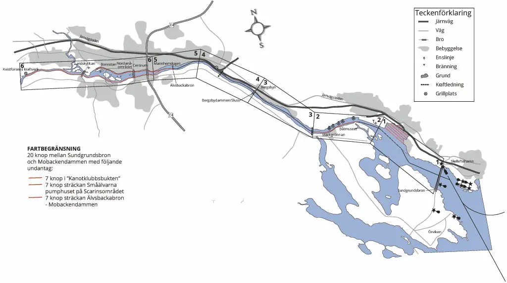
If you want to travel by boat up the Skellefteälven river, relatively large boats can take you up to Bergsbydammen. Unfortunately, further progress is limited by the size of the lock and not least by its depth.
Below Bergsbydammen, the direct contact with the sea means that the water level and depth in the lock chamber follows the sea level. Above, both the speed of the current and the water level depend on the seasonal or daily regulation of the water flow. This usually means that the water level is higher in early summer, but the current is also stronger then. However, heavy or prolonged rainfall in the mountain area can cause similar phenomena at other times of the year. In general, it can be said that the depth of the river is greater in the middle and in outer curves. Avoid inner curves. Between Manhemskajen and Lejonströmsbron the river is shallow in the middle. There you must choose one of the sides. Speed limits apply along the entire river.
Area 1
We start our boat trip where we leave chart 4211, at the Sundgrundsbron bridge. The bridge has a sail-free height of 9 meters. After that, it is best to stay in the middle of the river, although there is plenty of water even near the banks. On the port side you then get Degeröberget, which plunges steeply into the river. If you want to make a beach cut there, remember to have a long anchor line, as depths of over 20 meters are only one boat length from the shore. A single line marking the deep channel leading up the river has its signs on the old Scharin industrial area. On the starboard side we have Öhn where a shoal means that you should not stay too close to the shore. Outside Öhn, at a depth of about 4 meters, there is a large metal barrel anchored that serves as an outer mark for the single-marked channel. On Öhn's western cape there is a launching ramp that can be used by those with small boats. It is located where the Canoe Trail ends. A little bit north of there is Kanotudden, which has a nice summer café. With a spinning boat you can follow the land around the cape, but those with a slightly larger boat drive up a bit in the single line and approximately in the middle of the bay you steer right north. Inside the bay is a canoe course, when you have the rafts there in a straight line, you can steer towards them and then turn starboard.
When you reach the rafts, you can follow the canoe course to the headland. You'll have to ask people in the café if you can moor at the jetty (sometimes it's busy with canoeing activities), otherwise you can probably get permission to borrow a free mooring at the marina about 100 meters away. Watch out for the diving banks on both sides of the single line.
Area 2
For those who want to continue up the river, the single line follows up towards Klemensnäs. The navigable channel is at its narrowest point about 70 meters wide. A bit up the channel there are some red fishing balls, but you don't need to worry about them. They mark a purse seine area, which you can ignore except when fishing is in progress, but then the purse seiners will tell you the easiest way to pass. When you get to the old quays, you can keep close to them, although the depth is sufficient even relatively close to the southern side.
After passing the quay, the river turns southwest and then you keep midwater or closer to the southern edge of the river, as there are some old stone coffins under the water on the northern side and also extensive shoals.
Approximately in the middle of this stretch is the Stackgrönnan Boat Museum, where you can make a beach stop. Above the part of the quay that serves as
outdoor service, there is a floating dock where you can moor.
Area 3
When you come up to the starboard turn where there is a power line over
the river, just before this on the port side are the so-called "Småälvarna", a narrow river arm that flows into Fagerviken (Örviken) that can only be feared by small spinning boats. To continue upstream, keep closer to the northern shore to avoid the seaweed that grows on the southern side. You should then stay on this side until construction begins. Thereafter, you can again stay midstream, as there are no special obstacles, but to pass as far as possible from moored boats.
Area 4
As you approach Bergsbydammen, you enter the single line leading to the lock, north of the small islet. On the starboard side at the lock entrance there is a small mooring jetty to moor temporarily
if you need to wait your turn. The lock chamber is 11.5 meters x 3.5 meters and has a draft of 0.7-1.3 meters (affected by the water level in the sea). The sail-free height is about 4 meters and the lifting height is 1.5 - 2.0 meters. The width of the approach section allows a maximum boat width of 3.5 meters. When
you need to lock, you moor at the floating buoys in the lock wall, climb the ladders on the starboard side and lock from the control room.
Upstream of the lock, there is a mooring jetty that can be used for loading,
unloading or as a waiting jetty when locking downstream. When you leave the lock, head straight for the TV mast on Vitberget to avoid the strong current on the southern half (if the engine stops, the boat can be dragged towards the dam). In case of misfortune, there is a protective cable upstream of the dam gates to anchor in. Then keep in the middle of the river all the way up to the Victoria Bridge.
Area 5
At Moröskolan, the river bends to the southwest, and in that bend you should avoid the south side because of the seaweed. However, you should stay in the middle of the river in the next bend (starboard bend) as there are rocks and shoals on the north side. Just before you reach the Viktoria Bridge on the north side is the Manhemskajens marina. There is a trailer ramp just upstream of the quay.
Before the Victoria Bridge, you must decide your destination, as the deep channels then follow the edges of the river. Note that the clearance under the bridges is 3.5 meters.
North side
Area 6
If you follow the north side, you can get to central Skellefteå, Nordanå Outdoor and Cultural Center and Kyrkholmen.
You choose to walk between the two northernmost bridge pillars and then follow the shoreline at a distance of 10 - 20 meters. Just before you reach Parkbron, the municipality has placed a public floating dock where you can moor if you want to spend some time in the city center.
Pass under Parkbron between the northern abutment and the northernmost bridge column. Continue to follow the shoreline, especially at the height of the western tip of Ytterholmen where a large stone is located at the southern edge of the deep channel, so keep no more than 20 meters from the shore there.
South side
If you choose the south side, you can visit Rovön and Mobacken, among other places.
You pass the Viktoria Bridge between the two southernmost bridge pillars, after which the deep channel widens, so you can choose to pass the Park Bridge between the southern abutment and the second bridge pillar. The least current is between the landing stage and the first bridge column. After that, the channel narrows. In the opening between Ytterholmen and Karl-Fredriksholmen, a shoal begins, "Propellergrundet".
It extends almost the entire length of Karl-Fredrikholmen. Stay no further from the southern shore than 20 meters. Then it becomes wider again, and at Storholmen it is deep from shore to shore. Approximately the same width has the deep channel up to Lustholmen, and then it is deep the entire width of the river all the way up to Mobackendammen. Lejonströmsbron, Sweden's oldest wooden bridge, can be crossed between the southern landing stage and the third bridge column. Choose the opening that seems to have the least current. Rovön is a hiking area that may be worth a visit. At Mobacken, you can moor just downstream from the outlet of Bjurån. Once you have climbed the steep slope, there is a shelter with a barbecue area. If you walk upstream Bjurån, you will come to Mobacken church with a summer café and miniature golf course, and if you choose to cross the bridge over Bjurån, you will come to Mobacken's open-air swimming pool. The Mobacken dam puts an end to the journey but hopefully you have had a wonderful trip on the Skellefteälven river.
Please note that this text is a guide, you are responsible for your own journey along the river.